18 April, 2011

Springtime in Pisgah

Spring has brought forth its typical spread of wet weather. As it always seems to go in this land of the lush, the rain places itself nicely between the weekends, allowing us all to get outside and see how Friday's torrent has changed our landscape.

The on and off deluge that started Friday afternoon, extended into Saturday and threatened our riding plans. Wanting to DO something, I got up early and went to CrossFit. I believe this is this blogs introduction to CrossFit, something I've been doing since last September. It started as a Steve House inspired way to train for the climbing in Ecuador. Its continued beyond that as a way to train anaerobically, put on some lean muscle, work on flexibility, and stay in touch with my coaches on nutrition and stress management. CrossFit Asheville is one of the more complete CrossFit programs around from what I can see, and its more than just a bunch of people grunting out lifts.

Anyway, Saturday, 8:00 am was a "longer" CF workout, 15 minutes of work across 5 different stations. I bumped everything up; weights, jump heights, target heights for the workout so I was doing the prescribed workout, rather than scaling it. I was planning on burying myself and then crawling back home to enjoy a rainy Saturday. I finished the circuits and was shaking so bad my hand writing was illegible. Making breakfast seemed like an attainable goal.

Kicking back was the plan; until the email chain started going out for a late morning ride of Heartbreak. So 11:00am at the Dripolater in Black Mountain. That's a good 60 minutes of recovery. Perfect. Second new introduction; the Niner build. After four good years. and one tragic UPS accident that they denied over and over again, the Dieringer cracked, quite anticlimactically, on Sidehill Connector a few weeks back.
Plus
Equals
Thanks UPS. Everyone should be wary of paying for "insurance" when shipping; its a scam. So anyway....
Called in a favor over at Niner, and got myself a shiny, not quite new, Sir9.
The crew gathered, and took off on the rather flat road towards Montreat, and the Rainbow Road approach to Old Toll. Having complained about starting on the singlespeed from Ridgecrest, which throws you cold at Rattlesnake's steepest pitches within a mile, I wanted to try this more gradual approach. Just to get it out of the way; I'd rather do Rattlesnake. This is too long, too flat, and especially annoying after cresting the climb to Ridgecrest and then having to spinspinspin back to Black Mountain on 70.
Theme for the blog, now many paragraphs in: water. Old toll was a running torrent in most places. "Lines" where they do exist in the rockier sections were all loose, baby head rocks having been deposited in a new home overnight on Friday. When it wasn't running, it offered the more juvenile among us the opportunity to play puddle splashing games. This resulted in about thirty sprints as folks jockeyed for position to launch themselves into a puddle on the right or left track, splashing anyone behind them or caught off guard next to them.
"Hey Ed, where's that point on the ridge that I'm going to, in a stupor that can only be achieved by hours of anaerobic work sans breakfast, make a wrong turn and add the penalty lap?""Right about there"

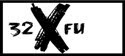
After two of our party flipped their ride, enjoying a very wet descent down Old Toll, Ed and I continued up. The early part of the Heartbreak descent was as fucked up as ever, and now wet as well. The ridge proper was in great shape. Tight tunnels of rhodo and mountain laurel occasionally giving way to gaps of blue sky. The Niner seems to descend well, and I'm loving my Manitou Minute on the front. It swallowed all the quick little roots of Heartbreak, and at 80mm, feels more stable on steep stuff than my old 10mm fork. On the way down, Ed had earned a little gap on me as a looked across the valley in a site seeing effort. In that same effort, I came up to Star Gap and dropped left. Something felt a little off, but this trail, new to me as a ORAMM virgin (I've saved enough to buy a new bike), felt a similar enough to the end of our normal Heartbreak loop that I didn't question it. Dry, woodsy, switchbacks, full shade, descending. Yep, this must be it. Dump out onto some grassy fire road: Nope, this ain't it. Back up all the switchbacks, found Ed at Stargap assuming I had suffered a skull fracturing crash, he had also climbed back up from the "true" end of the ride. Ahhh penalty miles. Wet, and getting colder, we dodged aggressive traffic up Mill Creek, and pedaled 32x20 and 32x22 (i'll claim the softer of those gears) along 70 back to Black Mountain. Clouds looming, a 40 mph wind reminded us never to use this modified route again on the single speeds. A decision that hardly effects my geared bike-less quiver. Goodbye Rainbow Road, it was nice to meet you.

Sunday I finally headed up to Shortoff to climb, something I've been wanting to do for the past 6 months. More on that later. This is too long as it is.

01 March, 2011

Visuals

Two things visual today, and I know, I know, I know; I have two more climbs to write up. I'm finally back in front of the computer tomorrow being paid by someone else, so that'll be motivation enough to write up my Illiniza Sur (Plan B surprise) and Cotopaxi climbs.

First things first because I've committed so many words to the memory of my adventures, I'll grace these pages with some photos for viewing.


With that out of the way, how about some amazing typography. And you thought fonts weren't cool. I have to credit KS for getting me to watch this movie with her. You click on the stream now button on Netflix, the screen darkens, and the films races headlong into the opening credits. The rest of the film was an impressive visual statement for a first time filmmaker. If you like that sort of thing, and can handle some disturbing imagery mixed in with the filmmaker's visually ambient representation of the synthetic psychedelic experience, I highly recommend "Enter the Void."


And because I'm still listening to Kanye's record daily, I stumbled on to his "All of the Lights" video (I did so because my little bro worked on a remix of Monster. He plays in a band with Ben Bronfman from time to time, Ben's got access to the Kanye masters because of his production credit on a couple tracks. I liken it to the two Ratatat remix albums in that they left the vocal tracks pretty much untouched and put an instrumental layer to it. I like it.) Kanye no doubt had access to Enter the Void, and the team that did it, though in my little bit of looking I can't find the outfit. The downside of it is, with 9 million views, the Kanye video seems to be driving a lot of people to the Enter the Void clip, with its mere 179,000 views. People are going to get the wrong idea. This one comment is saving the day.

I'm a let you finish but "Enter the Void" was the best psychedelic-transcendental-Fre­nch-film-in-English-set -in-Japan-about-post-traumatic­-stress- Freudian-psychology-and-the-Ti­betan-Book-of-the Dead of all time! :)

Kanye West, you thought we wouldn't notice.


05 February, 2011

Cayambe

Its now 6:30 pm in Quito and I´ve been awake since midnight. That´s how you climb when your route crosses the equator.

After a day of messing around on the lower glacier, lots of ipod time, food and naps at the hut at 15k, I settled into bed at 6pm. For 3 hours I tossed and turned with growing frustration; having to sleep is near impossible. Add in some harsh equatorial daylight and wind pouring through the leaky panes of the refugio, mixed with the anxiety of 19,000 feet, and rest doesn´t come easy.

Bryce woke me up at 12:00, planning on leaving in 30 minutes. We made some french toast, ate a few apples, and had some tea to warm us up. Bags were packed from the night before, and to save time we had harnesses and helmets on out of the hut.

The guide book calls this a 7 hour climb to the summit. Bryce says 7-9 or so for most of the times he´s been up. Its important to get off, or atleast well below the crevassed section up higher, before the very strong sun hits the route at 9am. The snow bridges become a gamble and crossing the larger crevasses below the summit becomes a non option. Thus the midnight start on all of these bigger climbs down here.

The first hour was a lot of hiking and scrambling. Relying on headlamps makes route finding a little tricky, as does the darkness of the new moon. We hit the glacier around 1:45, and cramponed up for the rest of the day.

This is my first actual glacier experience, having done a lot of vertical ice climbing in the past, but never walking on consolidated snow and ice at lower angles. It looks white and fluffy, but the 12 sharp points of your crampons barely make a dent. Your foot floats above the perfectly tractioned styrofoam surface. For 2 solid hours we made our way up the 35 degree slope neve and occasional hard ice. The lower glacier is pretty featureless, so there´s no crevasses, or noticable route denoters. Its just generally up. I´m sure Bryce was aiming at something, but in the dark, with 25 feet of visibility on acres of glacier, it just felt like one foot in front of the other, following the rope tied between us.

At 3:30 we ran into our first tricky route finding. A series of huge crevasses stood in our way. The plan from the start was to leave later than most of his clients because of the speed at which we´ve tackled the first two climbs. Rather than leave at 11:30 or 12, we slept in. The goal was to not reach this part of the climb until there was some predawn light. No luck. It was 3:30 in the morning and we were looking at a much changed crevasse feild since Bryce´s last summit a few weeks ago. This is rare for such a short time period, but glacial retreat via global warming is in full effect on the equator. Making it worse, recent snow had covered over everything, giving the illusion of solid ground, but actually thin snow bridges covering the large cracks in the ice.

With the help of my headlight, we spotted around looking for possible routes through the maze. We went left, up over a small ridge bordering a deep chasm of hard blue ice and found ourselves at a 3 foot wide, but very thin (according to Bryce) snow bridge across a 9 foot gap. The crevasse below was maybe 20 feet deep, and full of hard blue chandeliered icycle teeth. This is the only time in any of our climbs that Bryce has asked me to put him on belay. He stepped to the edge, with the rope kept tight, and darted across yelling back to me¨"think lite thoughts."

Minor challenge bested, we reached a point that he usually gets to via a different route, one that couldn´t be found in the dark and new snow conditions. A pitch and a half of vertical snow. The route description says 35 degree, but apparently the route has changed with the recent crevasse activity. This was 60 meters of 75-80 degree snow. Near vertical snow. Amazing to climb. The years of bullet hard Adirondak or Vermont ice with dulling crampons made this feel like climbing a ladder. Light kick with the foot, keeping the heel dropped to engage the secondary points, and you just kind of ran right up. Bryce and I simulclimbed this section tied short on our 30 meteres of rope, stopping to rest at the top under a nicely frozen overhanging wall of broken glacier.

We set a quick anchor, climbed one more pitch, moving seperatly, and had reached the end of the difficulty. We checked our watches, it was 4:45. We joked about, and then did, walk very slowly towards the summit. The goal being to have the sun rise while we were up there. Not much point summiting in the dark. Again, no luck. We got up there at 5:10 in the morning, fifty minutes before first light.

We piled on all of our clothes, sat on our packs, and moved in close, hoping to stay warm enough to wait it out. Sitting there in everything I had with me, slowly getting cold and falling asleep I called of our vigil. I knew it was for my benefit, but from a climbing perspective, it didn´t make sense. We were at 18,993 feet above sea level, probably 6k higher than I´ve been before this trip. No reason to sit around and see how my body reacted. Down we went, still guided by the LED beams of our headlamps.

More problems with the dark. We can´t find our descent point, which was at the top of that last pitch we did. Bryce had left two large snow pickets set for our use, but the 3 foot shafts of T-shaped aluminum were not making their whereabouts known. I led down off the summit, with Bryce´s direction, but we ended up well right of our point. Everything looks kind of the same up there. The only landmark a long crevasse that runs along the break from the summit dome. Its only 12-18 inches long, but it was 300 feet long. We remembered crossing over it, so we walked along it, occasionally looking down, and downclimbing looking for aluminum below. No luck.

I was getting pretty tired wandering around. Fitness always fails when a) your kind of lost and making no progress and b) you were convinced it was all downhill from here. We finally sat down again and waited for our accursed sun to rise so we´d have some light. Right around 6, in the ambient light coming around the horizon, we tried going far left, and 100 yards away saw two shiny pickets waiting for us at the top of a steep wall.

The down climb was uneventful, quick, and warm. We simul´d down the steep stuff. The daylight and overhead view allowed Bryce a better look at the crevasse feild, and we picked a much safer, and faster way through. We stripped off layers, and finally stopped for a snack in the warming sun, the thought having never occured to us before in the cold. Now everything around was lit up, and it was a rare clear day along the avenue of the volcanos. In the distance we could see Antisanna, Chimborazo (Tuesday´s climb), Cotopaxi (Friday´s Climb), the Ilinza´s (which i climbed last week) and a series of the other¨"big 10" down here. Lots of pictures and vistas on the way down made up for walking 6 hours in the dark. We finished scrambling down the last few hundred feet in view of the hut while hiding from the sun.

Route Details: Cayambe Standard Route: Grade II/PD 35 degree 1200m/3900 feet, summit height 5,789 meters, 18,993 feet.

02 February, 2011

Iliniza Norte

Yesterday was my condensed Iliza Norte climb. Initially we had intended to do this as a two day climb, approaching the hut in the afternoon, spending the night, and leaving in the morning for the summit. Bryce, my guide down here, is battling some kind of cold. Even the relatively "low" climb of Rucu had him feeling lackluster in the energy department, so it was decided he´d rest up for an extra day. No one wants a sick guide.

Tuesday´s one day blitz of Iliniza required we leave Quito at 4:45 in the morning. Luckily no one else was in my hostel room for my 9:30 bedtime and digging around in gear at 4:15 in the morning. Our driver got us to the base of the Ilinizas in about an hour and a half, making excellent use of some Honda truck they don´t make in the states. Lots of switching into 4WD low, and crawling up sandy washed out slopes and crossing rain swelled streams.

We started the gradual approach to the hut at around 6:15 in the morning. Sun was already well up behind us and the twin peaks of Ilinza Norte and Sur (North and South) were lit up against a splitter blue sky. Luckily I snapped a few photos from the lower ridge, it was the last time we´d see clear weather. On the upper ridge that approaches the hut, the trail steepens and turns to loose sand. We made conversation in very short, breathless sentences and switchbacked up a 5 foot wide path for a solid 30 minute push and reaached the hut at about 8:15.

The hut was manned and sold us a gatorade that we split as we talked to a swiss couple in Ecuador traveling and trekking, wishing they had brought ropes and crampons. Eager to get moving, we bid them farewell and they planned to follow us until thing got difficult.

The first part of the climb proper was a mix of steep trail, and some fouth class climbing as we maneuvered around some short walls and made our way higher on the ridge. The ridge line of Iliniza norte curves slightly to the left as you make your way up, and a few detours around pillars had me losing my sense of direction...looking off to the right as Bryce called me back to task behind me to the left. We down climbed a steep section of low 5th class to a snow field and then harnessed and roped up for a mix of snow and rock traverse to a saddle. I hadn´t walked on steep snow for a while, and the exposure to the left of us, along with Bryce´s reminder of "good footwork through here" had me accutely aware of my surroundings a few thousand feet above the base.

Solid snow travel set in, and we once again took a break to crampon up for the Paseo de los Muertes, which means path of the dead, I think. Rucu had a similarly named route, but this was the original. This section was a combination of steep snow, and some mixed ground as we rounded some small rock buttresses. Crossing these fingers or rock was the hardest part as the snow was less deep, and much softer near the warmer rock, and crampon placements felt a little shallow, and the rock didn´t offer much purchase for an axe. Passing them was a balancing act of trusting feet and hugging the narrow rock wall that was pushing you vertical.

One final steep snow section that followed a buttress straigt up led us to a saddle. When we were on the approach, Bryce commented on a wisp of moisture blowing over the summit, like you often see in mountain photos. I didn´t realize the significance of it in otherwise bluebird skies. I learned what it meant when we reached the summit. We had been engulfed in thick, actually soaking fog for the last 45 minutes, but reaching the saddle exposed the source of it all, a solid 40-50 mph wind blowing from the backside of the mountain. Bryce led up a steep rock section, and I followed, enjoying the suprisingly secure feel of crampon points on vertical rock. About 20 feet shy of Bryce, he yelled down through the already strong wind, "Don´t get blown off up here." Simple enough advice to follow.

I popped up to the summit to join Bryce, kind of unaware we were there already. The thick fog, and steepness of the pillars we had been climbing didn´t allow me to see the profile ahead. Suddenly I was up, 16,818 feet above sea level, and saw a cross with various ornaments hanging from it, all covered in about two inches of wind blown rime ice. I through a leg over the summit, Bryce snapped a few photos and yelled to me 3 feet away, ¨Let´s get the hell out of here"

The descent has us downclimb the last few steep pitches, and then continue straight down from one of the dicey buttress crossings. At first, descending involved front pointing and daggering in the axe, moving in loosely belayed pitches with the rope run over a horn. The slope relented its steepness, and eventually we were just stepping sideways foot over foot, axe up hill, and moving unbelayed but roped together. As we descended further and further the snow got softer, and felt deeper as we sunk in, slid a little and performed a controlled stumble for what seemed like forever. It was still pretty steep, and the snow feild dropped off into the fog. Both of our glasses were fogged up from all the moisture, but the sun was still too bright, even through the fog, to remove them. We continued in this half blind kind of walk for at least 45 minutes before the rock and dirt started to appear.

Stripped of gear, now wearing it all on our backs again, we made the hike back to the main trail that we had ascended to the hut, and continued our descent to the trailhead.

Our ascent had gone quickly, summitting just before 10 am, and now down just before noon. We had told the driver 3pm originally, and he thankfully said he´d be early just incase, arriving at 2. I took my boots off, layed down in the sun, bundled up from the wind and ate the lunch Bryce had made. Last time we ate on the summit, but this summit was just not going to allow us to do it, nor did the steep descent. Starving, Bryce´s homemade french toast and cheddar sandwhich was about the best thing I could imagine. We both sprawled out for a nap. I had the ipod out, listening to some Iron and Wine and lookng at the surrounding peaks that had become visible since our morning drop off.

Spot points

28 January, 2011

Rico Pinchacha

Heading up for the first climb of the trip today under cloudy skies down here low in Quito. Rucu is 15,656 and involves some 4th and low 5th class stuff. Been in Quito at 9300 for two days feeling good, we'll see how 15.5 feels today. Hope weather clears up.

Well the weather did not clear up so we got to hike and climb in a spitting rain for the way up, though it stopped for most of the rock sections and the rock dried rather quickly. Dull headache set in at about 15, but loosening the helmet did the trick. I was giving myself AMS symptoms. Summit was shrouded in fog, but very calm. Dined on nutella and pb sandwiches and grande queso Doritos with a successful acclimatization climb under me, close to 2500 ft higher than I've been previously. Sun came out for our quick descent down the more standard hiking route. Pictures to come but not till I get home unfortunately.